
Letters Home are excerpts from a father (Prof. Doug Toomey, Co-Chief Scientist) to his children back home.
Dear Ebba, Sofie, John and Family,
The R/V Langseth sailed into the caldera early this morning, guns on. I woke up earlier than usual, at 1:30 AM, so that I could stand fore of the wheelhouse and take in the moment. Three-thousand, six-hundred and seventy-five years ago, or thereabouts, it would not have been possible to sail this course, as we would have run aground on the northern flanks of the island. Today, those flanks are no more, and have not been since that cataclysmic eruption.
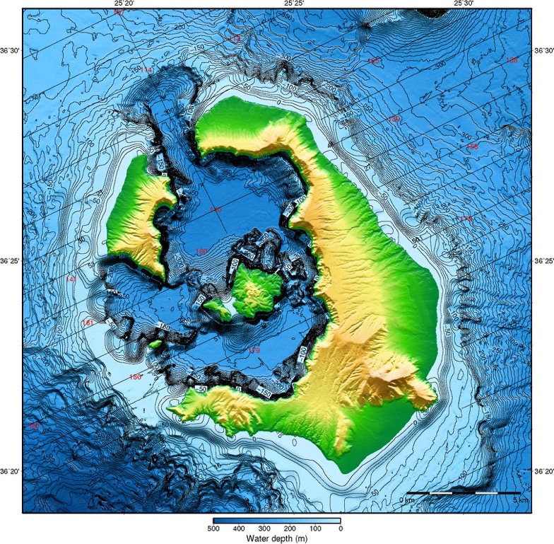
The evening was cool, with a light breeze and calm seas. As you know the moon is full, and I was hoping to see its crystalline reflection from the night sea. A thin veneer of clouds dulled those reflections, but not the night. Standing near the port side of the wheelhouse I can hear the 3.5 kHz echo sounder chirping away. To my ears, it sounds like two billiard balls being clapped together, with the timing of the claps adjusting to the water depth. In deeper water, the chirps come less often, every second or so, but as the depths shallow the chirps come more frequently. In this way, watching in the dark the lights of Oia and Thira, I can ‘see’ the flanks of the volcano rising gradually beneath the ship. Then, with surprising quickness, the interval between the chirps grows; we have entered the northern channel, where the flanks and cliffs of the volcano were blown up, out, and over the surrounding Med. You can see this gash in the attached map, an impressive feature. At it’s deepest, the gash is over 300 m beneath sea level. Less than a kilometer away, on land, the cliffs rise nearly an equal amount above the water.
Before coming here I would look at a map of the region and think to myself that it was a small, tiny island. Now, having traveled on the island and around it by ship, I am more respectful of the violence that has occurred here. And much of it transpired in a matter of minutes.
After entering the caldera we sail to the west of Nea Kameni and Palea Kameni, the two smaller islands. On the side scan sonar we can see reflections from the seafloor and the intensity or brightness of the reflections is related to the hardness of the bottom. In this way we can discern recent lava flows from sediment filled basins. The transit through the caldera is toward the west, up and over the shallows that guard the entrance. The 3.5 kHz pinger is now frantic, and as I listen to it complain I can see we are at 75 m, then 50 m, then just over 20 m of water depth. The ship draft is 6 m, so we are safe, but still in a large vessel there is a withholding of breath.
We exit the caldera, guns going off just 8 m from the hard, flat seafloor. Cups jump on the table every 90 seconds. 4 km beneath us lies molten magma, and I am imagining the waves as they bang and rattle the fire that burns down below.
Love,
Daddy
Bathymetric and topographic map of the Santorini region (Nomikou et al., 2014)